
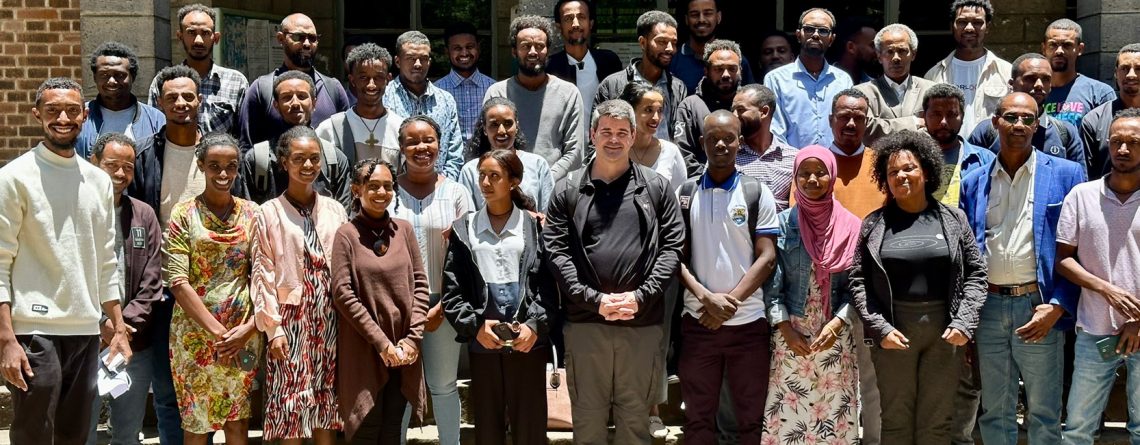

Kabale University student participates in a GIS expertise workshop in Ethiopia
Denis Kasozi, a third-year student from Kabale University’s Faculty of Computing, recently participated in a Geographic Information Systems (GIS) workshop at the University of Addis Ababa in Ethiopia. The workshop under the theme, “Mapping for Peace,” was conducted by The YouthMappers program in partnership with West Virginia University’s Department of Geology and Geography and took place from April 10th to 12th, 2024. This private event brought 40 undergraduate and graduate students from East Africa, including Kasozi, who were chosen for their leadership proposals that demonstrated a commitment to using OpenStreetMap data to improve understanding of vulnerable communities’ resilience. The course sought to provide participants with practical skills in GIS through a series of engaging workshops.
Among the trainers were Dr. Brent McCusker, the co-founder of YouthMappers and a Geography professor at West Virginia University, and Zola Manyangwa, a Geography Student at the University of Malawi and a 2018 YouthMappers fellow. Binyam Dele, the YouthMappers ambassador in Ethiopia, also offered his experience in mapping with the ID edition. The program covered a wide range of GIS topics, including data-gathering apps, advanced data analysis, participatory GIS concepts, mapping workflows, ethics, and community management. Student representatives from three universities, including Kasozi from Kabale University, actively engaged in these sessions.
Speaking to Kasozi, he expressed gratitude for the chance to broaden his GIS skill set and network with experts and peers from other Universities. He noted how the course provided significant hands-on experience, particularly in data processing, visualization, and geographical mapping. Kasozi’s involvement in the GIS workshop not only enhanced his academic experience but also established Kabale University as a significant contributor to the global GIS community.
He pledges to make significant contributions to the field of Geographic Information Systems, both locally and internationally.
Discover more from Kabale University News
Subscribe to get the latest posts sent to your email.


Leave a Reply